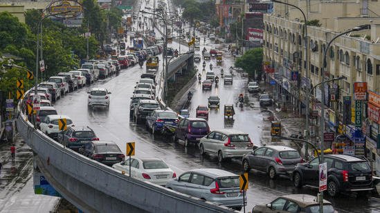
The Indian Meteorological Department (IMD) has issued a heavy rainfall warning for several regions of Tamil Nadu, signaling the possibility of significant weather disruptions over the next few days. As the monsoon season continues to make its presence felt, parts of the state are expected to witness intense rain, with potential risks to infrastructure, agriculture, and daily life. This alert comes amid a broader weather system affecting the southern states of India, which has already begun to influence conditions in Tamil Nadu.
Weather System Triggering Heavy Rain
According to the IMD, a low-pressure area has formed in the Bay of Bengal, intensifying weather conditions in the region. This system is expected to bring widespread rain, along with the possibility of isolated heavy downpours, to several districts of Tamil Nadu. The low-pressure area is moving westward, drawing moisture-laden winds from the Bay of Bengal and causing heavy rainfall, especially along the coastal and interior parts of the state.
The IMD’s forecast indicates that the monsoon trough, which governs rainfall distribution, will continue to affect Tamil Nadu and surrounding areas. As a result, the state is expected to experience heavy rainfall, particularly over the next three days.
Areas Affected by the Heavy Rainfall Warning
The IMD has identified several regions in Tamil Nadu that are likely to be impacted by the heavy rains. Coastal districts such as Chennai, Kanchipuram, Cuddalore, and Nagapattinam are likely to experience significant downpours. In addition to the coastal areas, districts in the interior, including Vellore, Salem, and Tiruvannamalai, may also face intense rainfall, along with the risk of localized flooding and waterlogging.
The IMD has issued a warning of ‘heavy to very heavy rainfall’ in some of these districts, with the possibility of isolated heavy rainfall exceeding 200 mm in certain areas. These rainfall events could lead to disruptions in transportation, power supply, and agricultural activities, particularly in rural and low-lying regions.
The warning is expected to remain in effect for the next 48-72 hours, with conditions being closely monitored by local authorities. IMD has advised residents in these areas to remain cautious and prepared for sudden weather changes, especially during the night hours when rainfall can intensify.
Forecast for the Next Three Days
The IMD’s detailed forecast suggests that the rainfall activity will peak on the second and third days of the warning period, with the possibility of widespread showers in most parts of the state. Here’s a breakdown of what to expect over the next three days:
Day 1 (Today – Heavy Rainfall): On the first day of the warning, widespread rain is expected across Tamil Nadu, particularly in the coastal regions. Moderate to heavy showers are likely to continue throughout the day, with the possibility of isolated heavy rainfall. Chennai and other coastal areas may see intermittent showers, while inland regions experience moderate rainfall.
Day 2 (Tomorrow – Very Heavy Rainfall): The intensity of rainfall is expected to increase significantly on the second day. Tamil Nadu, especially the coastal areas, will experience heavy to very heavy rainfall. Areas like Chennai, Cuddalore, and Nagapattinam may experience intense downpours. There is also a higher chance of localized flooding in vulnerable areas, and travelers should be cautious of waterlogging on roads.
Day 3 (Two Days from Now – Widespread Showers): On the third day, rainfall is expected to remain consistent, though slightly less intense compared to the second day. However, the likelihood of intermittent heavy rainfall persists, and regions in the interior may experience prolonged showers. The weather is expected to gradually ease towards the end of Day 3, but rain showers may continue sporadically in several areas.
Impact on Daily Life
The heavy rainfall expected in Tamil Nadu poses several risks, particularly to infrastructure, agriculture, and local livelihoods. Areas with poor drainage systems may experience waterlogging, affecting both road traffic and public transportation. In rural areas, standing water could delay harvesting operations, disrupt the movement of goods, and damage crops, especially those in flood-prone zones.
In addition, there is a heightened risk of landslides in hilly areas and regions with steep terrains, especially in districts such as Nilgiris and Dindigul. IMD has warned that such conditions could lead to road closures and travel disruptions, especially on the hilly routes.
The government has also issued advisories for residents to stay indoors during heavy rains and avoid unnecessary travel during peak rainfall hours. Local authorities have been instructed to be on alert, ready to deal with any emergency situations such as flooding or waterlogging.
Precautionary Measures
Residents are advised to take the following precautions:
- Stay Updated: Keep a close watch on weather updates and heed warnings issued by local authorities.
- Flood Preparedness: Ensure that homes, especially in flood-prone areas, are prepared for potential waterlogging. Move valuable items to higher ground and stock essential supplies.
- Avoid Travel: Unless absolutely necessary, avoid traveling during heavy rainfall hours. For those who must travel, take extra precautions, especially on waterlogged roads.
- Agricultural Safety: Farmers should take steps to protect crops from potential damage, particularly those in low-lying and flood-prone regions.
Tamil Nadu is set to experience heavy rainfall over the next few days, as the IMD’s forecast predicts widespread showers and localized flooding in several areas. While these rains are beneficial for agriculture, they also bring risks to infrastructure, transportation, and daily life. Authorities are monitoring the situation closely, and residents are urged to remain vigilant, follow safety guidelines, and stay updated on the latest weather alerts to minimize potential disruptions.

