


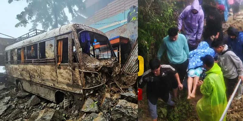
The Mizoram Mass Evacuations followed severe rainfall and flooding that disrupted normal life in parts of the state. More than 80 families were moved to safer locations in Lunglei district after the Khawthlangtuipui River overflowed following incessant rain. Officials reported the evacuations as precautionary measures amid rising water levels and landslide risks.
Moreover, the situation affected several locations across Mizoram, with landslides, rockfalls and other rain-related incidents reported at more than 29 sites during the July episode. Authorities continued monitoring vulnerable areas and providing assistance to affected residents.
North Tripura water conservation gets major boost at India Water Week 2026
Mizoram Mass Evacuations Follow River Overflow
The Mizoram Mass Evacuations became necessary after the Khawthlangtuipui River overflowed in Lunglei district, which borders Bangladesh. Continuous heavy rainfall over the preceding week caused water levels to rise, threatening homes in low-lying areas.
In Tlabung town, officials evacuated 42 families after rising water entered or partially submerged their houses. Meanwhile, around 40 families from Tipperaghat village were also moved to safer locations because of flooding.
Therefore, the combined figure exceeded 80 families. The evacuations helped residents move away from areas affected by rising water and flooding.
Furthermore, the response demonstrated the importance of early relocation when rainfall and river levels create immediate risks. Authorities can reduce exposure to hazards by moving vulnerable households before conditions deteriorate further.
Heavy Rain Creates Wider Disruption Across Mizoram
The Mizoram Mass Evacuations occurred alongside widespread weather-related disruptions. Officials reported landslides, rockfalls and other rain-related incidents at more than 29 locations across the state.
Additionally, National Highway 54 was blocked by a major landslide near Bualte village in Lunglei district. The disruption affected connectivity with the southern districts of Lawngtlai and Siaha, while several tourists remained stranded in the affected area.
Meanwhile, the Aizawl-Thenzawl-Lunglei highway also faced disruption after rockfall and landslide activity near Ngaizel on the southern outskirts of Aizawl. Consequently, road connectivity became another major concern during the period of heavy rainfall.
The situation highlighted the vulnerability of Mizoram’s hilly terrain during prolonged downpours. Slopes, rivers and road corridors can all face heightened risks when heavy rainfall continues.
Disaster Response Focuses on Safer Locations
The Mizoram Mass Evacuations also highlighted the role of local disaster-response mechanisms. Officials moved affected households toward safer areas while monitoring the developing flood situation.
Moreover, Mizoram’s disaster-management system uses local officials and designated response structures to coordinate assistance during calamities. More recently, Disaster Management and Rehabilitation Minister Lalnilawma urged residents to report landslides, road blockages and other emergencies immediately as heavy rain affected several parts of the state.
The state has also deployed Zonal Officers in different localities, while disaster-management committees operate at village and local levels under the supervision of deputy commissioners.
Therefore, community reporting remains an important part of the response system. Timely information can help authorities identify affected areas and organise assistance more quickly.
Mizoram Mass Evacuations Highlight Monsoon Preparedness
The Mizoram Mass Evacuations underline the continuing importance of monsoon preparedness in the state. Although the July evacuation involved more than 80 families in Lunglei district, the wider rainfall episode affected roads and communities in multiple locations.
Furthermore, recent heavy rain has continued to create infrastructure concerns in Mizoram. In September, soil erosion affected railway tracks between Jamira in Assam and Bairabi in Mizoram, prompting restoration work and disruption to train services.
Similarly, recent rainfall has triggered landslides and road disruptions, prompting the state disaster-management minister to ask residents to remain vigilant and report emergencies.
Consequently, evacuation planning, early warnings and rapid reporting remain important during periods of intense rainfall. Authorities must also continue monitoring rivers, roads and other vulnerable infrastructure.
Conclusion
The Mizoram Mass Evacuations involved more than 80 families who were moved to safer locations in Lunglei district after the Khawthlangtuipui River overflowed following prolonged heavy rainfall. The episode also brought landslides, rockfalls and road disruptions across several parts of the state.
Moreover, the evacuation demonstrates the importance of timely disaster response in vulnerable areas. Continued rainfall monitoring, community cooperation and rapid reporting can help authorities protect residents when flooding and landslide risks increase.
FAQs
1. How many families were evacuated in Mizoram?
More than 80 families were evacuated to safer locations during the reported flooding episode in Lunglei district.
2. Why were the families evacuated?
The Khawthlangtuipui River overflowed after prolonged heavy rainfall, causing flooding in vulnerable areas.
3. Where did the evacuations take place?
The reported evacuations took place in Tlabung town and Tipperaghat village in Lunglei district.
4. Did heavy rain affect other parts of Mizoram?
Yes. Officials reported landslides, rockfalls and other rain-related incidents at more than 29 locations during the episode.
5. What is the significance of the Mizoram Mass Evacuations?
The evacuation highlights the importance of early disaster response and moving vulnerable families to safer locations when flooding risks increase.