


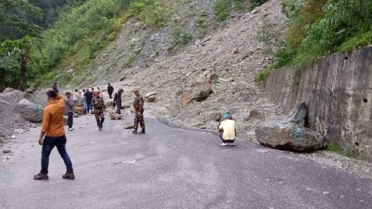
The Naga Tosa Road Blockage in North Sikkim formed part of a wider weather-related disruption after intense rainfall affected Mangan district. Landslide debris along the newly cut Naga–Tosa Road contributed to temporary water accumulation, while the Teesta and Chyakoong rivers also experienced disruption. Authorities continued monitoring the affected areas as rainfall and unstable slopes created additional risks.
Bana Kaih 3.0 Brings Major Youth Jobs and Farm Support in Mizoram
Naga Tosa Road Blockage Adds to Weather Damage
The Naga Tosa Road Blockage followed a major landslide in Mangan district during the intervening night of September 5 and 6, 2026. A substantial section of hillside along the newly cut Naga–Tosa Road near the Theng Tunnel collapsed, sending debris into the surrounding area.
Meanwhile, the landslide affected nearby waterways and temporarily disrupted the flow of the Teesta and Chyakoong rivers. Authorities therefore monitored river conditions and alerted vulnerable downstream areas as a precaution.
Additionally, heavy rainfall affected parts of North Sikkim, increasing concerns over further slope failures and water-related disruptions. The mountainous terrain makes such events particularly challenging because road blockages can restrict access to affected locations.
However, initial reports indicated no deaths or injuries from the landslide, despite property and infrastructure damage.
Teesta River Faces Heavy Rainfall Impact
The Naga Tosa Road Blockage occurred alongside unusual changes in the local water system. High-intensity rainfall and landslide debris placed additional pressure on river channels, with reports indicating temporary water accumulation around the Teesta and Chyakoong rivers.
Reports from the affected area also described heavy rainfall and landslide activity around Theeng and Chungthang. Consequently, local infrastructure faced pressure from both unstable slopes and increased water movement.
The Teesta later returned to normal flow, while monitoring posts reportedly recorded normal water levels. Nevertheless, officials remained attentive to the possibility of further changes because additional rainfall could trigger fresh debris movement.
Therefore, the reported overflow and minor infrastructure damage should be understood within the broader context of a rapidly changing weather and landslide situation. A detailed assessment would be required to establish the precise locations and extent of any riverbank overflow.
Water Accumulation Raises Infrastructure Concerns
The Naga Tosa Road Blockage also demonstrated how landslide debris can alter natural drainage patterns. When large quantities of soil and rock enter a drainage channel, water can temporarily accumulate or change direction.
In the Naga Forest area, debris reportedly contributed to the formation of a lake-like water body. Similarly, the wider landslide caused temporary changes in the nearby river system.
Moreover, roads, bridges and other infrastructure located close to rivers can face additional pressure when water levels rise. Even relatively minor damage can create access difficulties in remote Himalayan areas.
Meanwhile, authorities have to monitor both the damaged infrastructure and surrounding slopes. Further rainfall could loosen already unstable material and create additional blockages.
The situation therefore highlights the importance of rapid assessment after landslides. Officials need to understand how debris has affected roads, drainage channels and waterways before determining the full extent of infrastructure damage.
North Sikkim Remains Under Close Monitoring
The Naga Tosa Road Blockage highlights the vulnerability of North Sikkim’s infrastructure to intense rainfall and landslides. Mangan district contains steep mountainous terrain, where monsoon rainfall can contribute to slope instability and debris movement.
Furthermore, the latest incident demonstrates how one landslide can create several connected problems. Road access can become difficult, waterways can experience temporary obstruction, and communication services can face disruption at the same time.
The situation also reinforces the importance of river monitoring. Although the Teesta subsequently returned to normal flow, authorities remained cautious because water conditions can change quickly after a landslide.
Additionally, Sikkim faces broader flood and landslide risks because of its Himalayan geography. Recent assessments have also highlighted concerns surrounding high-risk glacial lakes and the need for stronger early-warning and mitigation systems.
Consequently, the latest event adds to the importance of resilient infrastructure, effective drainage systems and reliable monitoring across vulnerable areas of North Sikkim.
Conclusion
The Naga Tosa Road Blockage remains part of a wider weather-related disruption in North Sikkim after a major landslide affected Mangan district. The event temporarily disrupted the Teesta and Chyakoong rivers, while intense rainfall contributed to difficult conditions across the region.
Although reports indicate temporary water accumulation and infrastructure damage, the Teesta later returned to normal flow. Authorities continue to face the task of monitoring unstable slopes, waterways and damaged infrastructure as the region remains vulnerable to further heavy rainfall.
FAQs
1. What happened during the Naga Tosa Road Blockage?
A major landslide affected the newly cut Naga–Tosa Road near the Theng Tunnel in Mangan district, depositing substantial debris in the area.
2. Was the Teesta River affected?
Yes. The wider landslide temporarily disrupted the Teesta’s flow. Reports later indicated that the river returned to normal flow.
3. Did heavy rain contribute to the situation?
Heavy rainfall affected Sikkim during the period, while the combination of rainfall and unstable mountainous terrain increased landslide and flood-related concerns.
4. Were there casualties?
Initial reports indicated no deaths or injuries from the Mangan landslide, despite property damage.
5. Why is the Naga Tosa Road Blockage significant?
It demonstrates how a landslide can simultaneously affect roads, waterways and surrounding infrastructure in a mountainous region.