


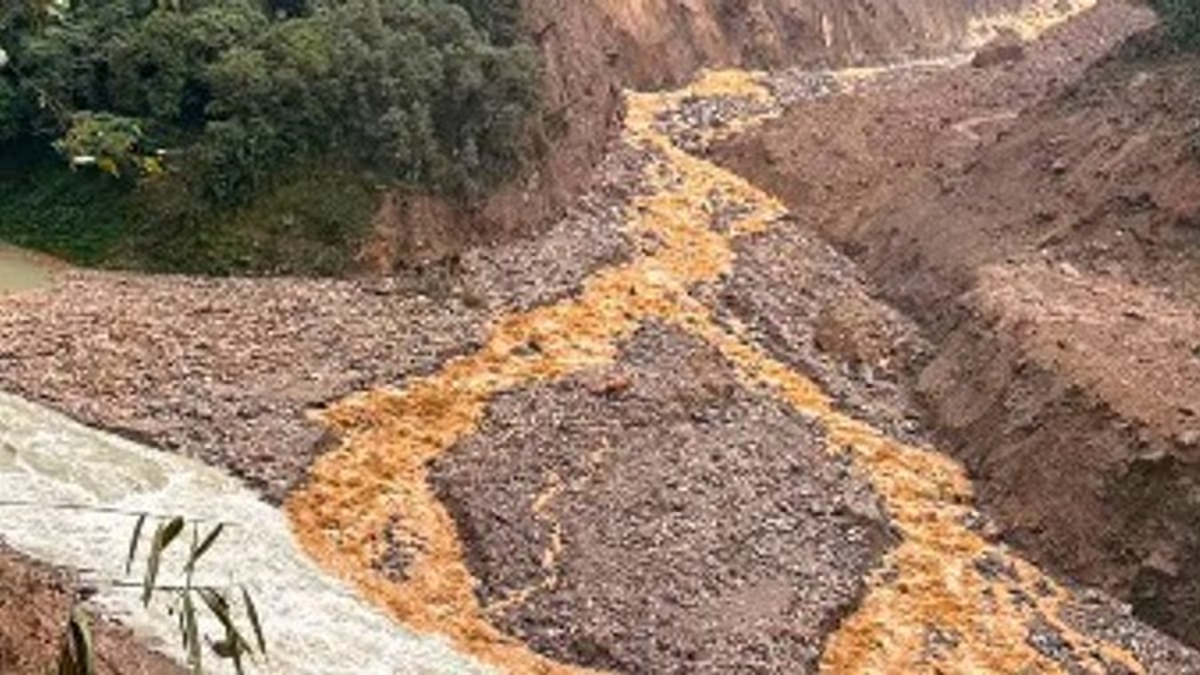
The Naga Tosa Road Blockage in North Sikkim has drawn attention after landslide debris along the newly cut Naga–Tosa Road in the Naga Forest area reportedly led to the temporary formation of a lake-like water body. The development followed a major landslide during the intervening night of September 5 and 6, 2026. Reports also indicated that debris affected the flow of nearby rivers in Mangan district.
Bana Kaih 3.0 Brings Major Youth Jobs and Farm Support in Mizoram
Naga Tosa Road Blockage Follows Major Landslide
The Naga Tosa Road Blockage occurred after a substantial section of hillside along the newly cut road gave way in the Naga Forest area of North Sikkim. Reports identified the affected road section as part of the Naga–Tosa route, where the landslide deposited a significant volume of soil, rocks and other debris.
The incident formed part of a wider landslide event in Mangan district during the night of September 5–6. According to reports, the slope failure occurred above the Chyakoong River and also affected the nearby Teesta River system.
Meanwhile, the road cutting itself became an important part of the incident because the newly developed route passes through steep Himalayan terrain. Such terrain remains particularly vulnerable to slope instability, especially during periods of heavy rainfall.
The debris reportedly accumulated in a manner that temporarily obstructed the movement of water. Consequently, water began collecting behind or around the deposited material, creating a lake-like appearance in the affected area.
However, the temporary water body should not automatically be described as a permanent lake. Its formation appears connected to the landslide debris and altered drainage conditions following the slope failure.
Debris Creates Temporary Lake-Like Water Body
The formation of the temporary lake-like water body added another dimension to the Naga Tosa Road Blockage. When large amounts of earth and rock enter a drainage channel, even a temporary obstruction can change the direction and speed of flowing water.
In this case, debris from the landslide reportedly accumulated along the newly cut road section and contributed to water pooling in the surrounding area. The resulting formation attracted attention because of its unusual appearance and its connection with the recent landslide.
Additionally, reports from the wider area indicated that the landslide partially obstructed the Teesta and Chyakoong rivers near their confluence. Financial Express reported that water accumulated in the two rivers after the landslide, while the Teesta subsequently returned to normal flow.
Therefore, the temporary lake-like formation needs to be viewed as part of a broader disruption to natural drainage caused by the slope failure. The precise size, depth and duration of the water body would require direct assessment by local authorities or technical teams.
Furthermore, temporary water accumulation behind landslide debris can change rapidly if the debris shifts or water finds another outlet. For that reason, visual observations alone cannot establish the stability of the formation.
Naga Tosa Road Blockage Raises Monitoring Concerns
The Naga Tosa Road Blockage also highlights the challenges involved in maintaining transportation infrastructure across Sikkim’s mountainous terrain. Mangan district contains steep slopes and extensive mountain valleys, where landslides frequently affect roads and connectivity.
The latest incident occurred during a period when heavy rainfall and landslide risks remained a concern across Sikkim. The India Meteorological Department had warned of isolated heavy rainfall in parts of the state, while reports linked the recent landslide to disruption along the Teesta and Chyakoong river system.
Moreover, the incident demonstrates why newly constructed road sections require close monitoring during the monsoon period. Fresh road cutting can alter local slopes and drainage patterns, although the available reports do not establish that the road construction itself caused the landslide.
Authorities therefore need to assess the affected slope, road surface, drainage channels and surrounding water accumulation before determining the extent of damage.
Meanwhile, downstream areas also require attention whenever a landslide partially blocks a river. Even if water levels remain normal initially, a sudden movement of debris can alter the flow conditions. Reports indicated that vulnerable downstream areas received precautionary alerts after the Sikkim landslide.
The situation also comes against a broader backdrop of disaster-preparedness concerns in Sikkim. The state has been examining risks associated with landslides, flash floods and glacial lakes, particularly because Himalayan communities face multiple forms of water-related hazards.
Sikkim Landslide Highlights Himalayan Infrastructure Risks
The Naga Tosa Road Blockage underlines the difficult relationship between infrastructure expansion and the fragile Himalayan landscape. Roads remain essential for connecting remote communities, supporting economic activity and improving access to public services. At the same time, construction and road cutting require careful management in steep and geologically sensitive areas.
The latest landslide demonstrates how quickly natural events can affect newly developed infrastructure. Furthermore, debris can create secondary problems by obstructing streams, changing drainage routes and temporarily storing large amounts of water.
However, authorities have not reported deaths or injuries from the Mangan landslide in the initial reports available. The Teesta also subsequently resumed normal flow, while monitoring points reportedly recorded normal water levels.
That development provides some immediate reassurance. Nevertheless, the temporary lake-like water body and the debris along the road remain important indicators of the need for continued monitoring.
Additionally, the event highlights the importance of early warning systems and rapid communication in mountainous districts. Residents and road users can face rapidly changing conditions when heavy rain combines with unstable slopes and blocked drainage channels.
Sikkim has already increased attention on Himalayan hazard preparedness. Recent reporting has highlighted state and central efforts to identify and mitigate high-risk glacial lakes and improve early-warning mechanisms.
Consequently, incidents such as the Naga–Tosa landslide can contribute to wider discussions about resilient road construction, slope stabilisation, drainage management and disaster preparedness across the Himalayan region.
Conclusion
The Naga Tosa Road Blockage has created a notable situation in North Sikkim after landslide debris along the newly cut road section reportedly contributed to the temporary formation of a lake-like water body. The incident also affected nearby river flows in Mangan district, although reports later indicated that the Teesta returned to normal conditions.
For now, the development remains primarily a reminder of the vulnerability of mountain infrastructure during periods of heavy rainfall. Moreover, continued monitoring of the debris, water accumulation and surrounding slopes will remain important until authorities determine that conditions have stabilised.