

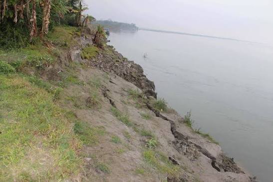
Majuli Island erosion threat remains a serious concern as the Brahmaputra and its tributaries continue to reshape the river island after the monsoon season. Recurrent flooding, strong river currents and sediment movement have made riverbank erosion a long-standing challenge for communities across Majuli.
Government data shows the scale of the wider problem. Assam has lost around 930 square kilometres of land to river erosion since 1950, while Majuli alone has lost dozens of villages and thousands of bighas of land.
The post-monsoon period does not immediately remove the threat. Instead, weakened banks and changing river channels can leave vulnerable areas exposed to further erosion. Meanwhile, authorities continue to use embankments and river-training measures to protect settlements and agricultural land.
Major Breakthrough: Chakhesang Youth Agitation Ends After Nagaland Forest Department Settlement
Majuli Island Erosion Threat Grows After Monsoon
The Majuli Island erosion threat is closely connected to the island’s location within the Brahmaputra river system. The island lies between the Brahmaputra and its associated channels, while the Subansiri River also influences its western side. This setting leaves Majuli highly exposed to changes in river flow and sediment movement.
Assam’s Water Resources Department describes riverbank erosion as a major problem across the state’s Brahmaputra and tributary systems. The department estimates that rivers have eroded about 4.27 lakh hectares across Assam since 1950.
Majuli remains one of the areas most affected by this process. Government information says roughly 60% of the island’s original area has already been engulfed by the Brahmaputra.
Recent figures further highlight the continuing pressure. Assam’s Revenue and Disaster Management Minister Keshab Mahanta told the state Assembly in July 2026 that erosion had completely affected 64 villages in Majuli and partially affected another 23.
The same assessment recorded around 15,600 bighas of land lost in Majuli and more than 15,400 people affected.
Consequently, erosion remains more than an environmental concern. It can affect homes, farmland, roads, community infrastructure and the livelihoods of residents living near vulnerable riverbanks.
Brahmaputra Erosion Continues to Affect Communities
The Majuli Island erosion threat has created repeated displacement pressures for riverbank communities. In Kordoiguri, erosion-affected families have faced the prospect of rebuilding their lives again after losing land to the Brahmaputra over several years.
Such displacement can create long-term social and economic difficulties. Families that lose agricultural land may face reduced income, while relocation can disrupt access to schools, transport, markets and other essential services.
Moreover, erosion can occur alongside flooding rather than as a completely separate process. High river levels can weaken banks, while strong currents remove sediment and gradually alter the shape of the shoreline.
The Brahmaputra’s changing channels make the problem particularly difficult to manage. Unlike a fixed shoreline, a riverbank can shift as water flow, sediment deposits and channel patterns change.
A 2026 scientific study provides a much longer perspective on these processes. Researchers reconstructed nearly 4,000 years of climate and vegetation history from sediment collected on Majuli. Their analysis also examined grain sizes to understand changes in river dynamics and flood intensity.
The study found evidence of changing hydrodynamic conditions over long periods. It also highlighted Majuli’s vulnerability to recurrent flooding, erosion, deforestation and other environmental pressures.
Therefore, recent erosion cannot be viewed only through a single monsoon season. The island’s landscape has been shaped by river processes over centuries, while modern pressures have increased the vulnerability of communities and ecosystems.
Government Uses River Training and Protection Measures
The Majuli Island erosion threat has prompted several protection measures from government agencies. Assam’s Soil Conservation Department lists bank stabilisation, boulder pitching and boulder spurs among the river-training measures used or proposed in Majuli.
Bank stabilisation aims to strengthen vulnerable slopes. Boulder spurs, meanwhile, can redirect river currents away from exposed sections of the bank. Officials also consider loop cutting in selected locations to modify river channels and reduce the risk of overflow.
Majuli’s Water Resources Department also maintains an extensive embankment network. Government data lists about 116.44 kilometres of flood embankments in the district, including systems along the Brahmaputra and Subansiri.
The department says 90% of the embankment crest in Majuli has been converted to blacktop. It has also identified vulnerable sections and stated that precautionary measures are undertaken before the flood season.
Earlier, the Brahmaputra Board received central approval for a major Majuli protection scheme. The 2017 project included geo-bag bank revetment across 27 kilometres at 14 locations, RCC porcupine works at 41 locations, a sluice and a pilot channel.
However, erosion remains difficult to control permanently because river conditions change continuously. A protection structure that works under one flow pattern may face different pressures when the river shifts its channel.
For that reason, authorities increasingly need to combine structural protection with continuous monitoring and locally appropriate land-management measures.
Nature-Based Solutions Offer Another Approach
The Majuli Island erosion threat has also encouraged interest in nature-based approaches. In Pathorichuk village, residents have used Kanchan trees along the Brahmaputra bank as a local erosion-control measure.
According to reporting from 2025, residents said the deep-rooted trees helped hold soil together and reduced the impact of river currents in the area. Local communities subsequently urged authorities to consider wider plantation in erosion-prone areas.
Such community-led measures do not automatically replace engineering interventions. Nevertheless, vegetation can contribute to soil stability and ecological restoration when species and planting locations suit local conditions.
Assam’s Soil Conservation Department also lists protective afforestation as one of its measures. The programme aims to provide permanent vegetation cover on suitable riverine and degraded land while supporting ecological balance.
Furthermore, nature-based measures can complement existing river-training works. Vegetation, soil conservation and carefully planned engineering structures can address different aspects of bank vulnerability.
The approach requires careful assessment, however. Riverbank conditions vary widely, and planting alone cannot guarantee protection against major changes in river flow.
Consequently, scientific monitoring remains essential. Authorities need to understand where erosion is accelerating, how channels are shifting and which interventions provide durable protection.
Long-Term Planning Becomes Increasingly Important
The Majuli Island erosion threat highlights the need for long-term planning beyond individual flood seasons. Repeated land loss can gradually change settlement patterns and place additional pressure on already vulnerable communities.
The 2026 palaeoecological study provides useful historical context for such planning. Researchers said the findings could support biodiversity conservation, wetland restoration, sustainable land-use planning and climate adaptation in the Upper Brahmaputra Valley.
This longer perspective is important because river erosion results from several interacting factors. Climate variability, rainfall, flooding, sediment movement and human activity can influence how river systems evolve.
Moreover, erosion protection must account for the needs of affected residents. Infrastructure protection alone may not address the consequences faced by families who have already lost land or require relocation.
The July 2026 Assembly figures underline the scale of the challenge. With 64 villages completely affected and 23 partially affected in Majuli, erosion has already produced substantial human and land losses.
Therefore, future planning may need to combine river monitoring, targeted bank protection, land-use planning, ecological restoration and support for communities facing repeated displacement.
The post-monsoon period provides an important opportunity to assess vulnerable stretches before the next major flood cycle. At the same time, authorities must continue monitoring river behaviour rather than relying solely on fixed protection structures.
Conclusion
The Majuli Island erosion threat remains a major environmental and social challenge after another monsoon season. Assam’s official data shows extensive land loss across the state, while Majuli has experienced particularly severe impacts from Brahmaputra erosion.
Government agencies have developed embankments, river-training structures, bank stabilisation projects and other measures to reduce the damage. Meanwhile, local communities have also explored nature-based approaches such as tree planting along vulnerable banks.
The latest scientific research adds another dimension by showing how Majuli’s river and environmental systems have changed over thousands of years.
As the island enters the post-monsoon period, continued monitoring and long-term planning will remain essential to protect vulnerable communities, agricultural land and Majuli’s distinctive ecological and cultural landscape.
FAQs
Why is the Majuli Island erosion threat so serious?
The Majuli Island erosion threat is serious because the Brahmaputra and associated rivers continually reshape the island. Erosion has already destroyed numerous villages and affected thousands of residents.
How much land has Majuli lost to erosion?
Government information says around 60% of Majuli’s original area has already been engulfed by the Brahmaputra.
How many Majuli villages have been affected by erosion?
According to figures presented in the Assam Assembly in July 2026, 64 villages in Majuli had been completely affected by erosion, while another 23 had been partially affected.
What measures are used to control erosion in Majuli?
Authorities use measures including bank stabilisation, boulder pitching, boulder spurs, embankments and other river-training works. Protective afforestation is also used as an environmental measure.
Can tree planting help reduce riverbank erosion?
Tree planting can contribute to bank stability in suitable locations. A community-led Kanchan tree initiative in Pathorichuk has been reported as a local response to erosion, although vegetation cannot replace all engineering and monitoring measures.