


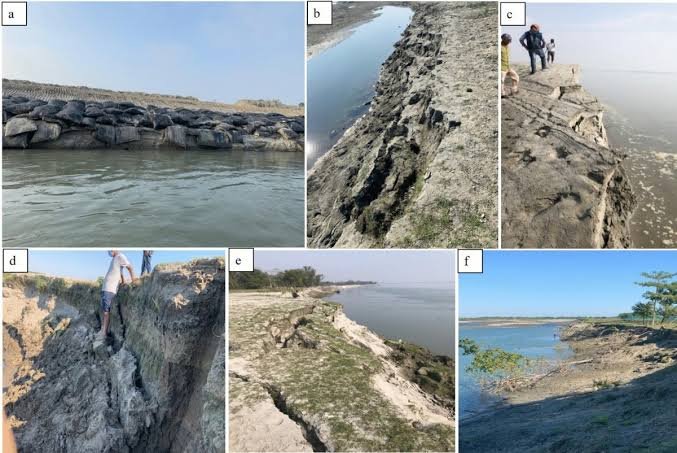
The Majuli Island Erosion Preventive Measures remain a major priority for Assam because the Brahmaputra continues to expose the river island to severe flooding and bank erosion. The Water Resources Department maintains embankments and undertakes riverbank protection works across vulnerable areas.
Recent government procurement activity also shows that the Majuli Water Resources Division continues to advance works under its 2025–26 programme. However, available official records do not specifically confirm that the department has accelerated a new stone-crating drive. Instead, documented measures include bank stabilisation, boulder pitching, embankment strengthening and anti-erosion works.
Pakyong Light Vehicle Access Allowed as Routes Remain Under Strict Surveillance
Majuli Island Erosion Preventive Measures Address a Longstanding Threat
The Majuli Island Erosion Preventive Measures respond to a geographical challenge that has affected the island for decades. Majuli lies within the dynamic Brahmaputra river system, with the river surrounding major parts of the island and its adjoining areas.
According to the Assam Water Resources Department, about 60% of Majuli’s original area has already been engulfed by river erosion. The department also identifies erosion along the Brahmaputra and its tributaries as one of Assam’s major environmental and infrastructure challenges.
The Majuli district administration similarly describes the island as highly vulnerable to both flooding and erosion. Official district information says Majuli’s geographical area had declined substantially because of erosion, while its chapories and main island remain exposed to recurrent flood risks.
Therefore, protecting the riverbank requires continuous intervention rather than a one-time construction programme. Moreover, changing river channels and heavy sediment movement make individual vulnerable reaches subject to changing levels of risk.
The Water Resources Department’s mandate includes anti-erosion works, river training, embankment strengthening and flood-protection measures. Consequently, the department combines structural protection with monitoring of vulnerable reaches and preparation for flood conditions.
Boulder Pitching Supports Vulnerable Riverbanks
The Majuli Island Erosion Preventive Measures include boulder pitching as one established method of protecting exposed slopes. The Majuli Soil Conservation Department’s official records describe bank stabilisation through slope maintenance and boulder pitching.
Government records list several completed projects in Majuli involving bank stabilisation and boulder pitching. These include the Kherkati River Training Project at Ratanpur Miri, the Kalia-Jokaibowa Riverine Land Protection and Land Development Project, and the Bheuchuk Kumarbari Riverine Land Protection Project.
These interventions demonstrate that stone-based bank protection has already formed part of Majuli’s broader river-training strategy. However, the terminology used in official records is generally “boulder pitching” and “bank stabilisation” rather than a newly announced “stone-crating” programme.
The same government information identifies boulder spurs as another method. These structures can help redirect river currents away from vulnerable banks. Additionally, river training can include measures designed to reduce the impact of changing channels.
Therefore, the protection strategy does not depend on a single engineering technique. Instead, officials can select different measures according to river behaviour, bank conditions and the vulnerability of individual locations.
The approach remains particularly important in Majuli because the Brahmaputra’s morphology changes continuously. As a result, protection structures must respond to local conditions rather than follow one uniform model.
Water Resources Division Continues Majuli Works
The Majuli Island Erosion Preventive Measures also involve the district’s dedicated Water Resources Division. The division has responsibility for flood-protection infrastructure across Majuli and operates from Garmur.
Official district records state that Majuli has more than 116 kilometres of flood embankments, including Brahmaputra and Subansiri dykes. The department has also identified vulnerable reaches and described measures to strengthen and monitor them before flood seasons.
The Assam Water Resources Department’s wider flood-management programme includes construction and strengthening of embankments, river training, anti-erosion works and town-protection projects. The department also undertakes surveys and prepares detailed project reports for flood and erosion-control schemes.
Furthermore, the department maintains material banks containing items such as geo-bags, cement bags, jumbo geo-bags, gunny bags and porcupine bars. One such material bank is planned at Majuli to improve preparedness when emergency flood and erosion situations develop.
Current procurement records provide another indication of continuing activity. An Assam government tender issued in July 2026 under the Department of Water Resources concerns works under the Majuli Water Resources Division. Another active tender record remained listed in September 2026.
However, tender activity should not automatically be described as completed construction. A tender indicates procurement or execution planning, while physical completion requires separate confirmation. This distinction remains important when assessing the current status of erosion-prevention works.
Earlier Anti-Erosion Projects Provide a Foundation
The Majuli Island Erosion Preventive Measures build on several major interventions implemented over the years. The Brahmaputra Board has previously undertaken extensive flood and erosion-protection work on the island.
A major government-backed scheme approved in 2017 carried an estimated cost of ₹233.57 crore. Its components included bank revetment using geo-bags over a 27-kilometre reach at 14 locations, RCC porcupine works at 41 locations, a sluice and a pilot channel.
Earlier protection works also included strengthening of embankments, construction of spurs and bank revetment. The government reported that these interventions helped contain erosion at many vulnerable locations and contributed to changes in river morphology.
A later government document reported that the major Majuli protection scheme had achieved substantial physical progress by March 2023. The project continued to focus on bank revetment and RCC porcupine structures as important anti-erosion measures.
These earlier projects provide an important engineering foundation for current efforts. Nevertheless, continued erosion demonstrates why protection cannot stop after completion of one project. River conditions can change, while existing structures require inspection, repair and maintenance.
Moreover, a 2026 government study examining nearly 4,000 years of climate and vegetation history on Majuli highlighted the island’s long exposure to changing flood dynamics and intense riverbank erosion. Such research can contribute to longer-term adaptation planning for vulnerable communities.
Conclusion
The Majuli Island Erosion Preventive Measures remain essential to protecting Assam’s vulnerable river island from the continuing effects of Brahmaputra erosion and flooding. Government records confirm ongoing responsibilities for embankment maintenance, river training, bank stabilisation and anti-erosion works across Majuli.
Although the specific claim of a newly accelerated “stone-crating” drive is not confirmed in the latest official records, boulder pitching and other stone-based bank-stabilisation techniques have formed part of Majuli’s protection programme. Current procurement activity also indicates continuing work under the Majuli Water Resources Division.
Therefore, the island’s protection effort remains a continuing process involving structural works, monitoring, emergency preparedness and long-term river-management planning. Maintaining vulnerable banks will remain important for protecting communities, agricultural land and infrastructure across Majuli.
FAQs
What are the Majuli Island Erosion Preventive Measures?
The Majuli Island Erosion Preventive Measures include embankment strengthening, bank stabilisation, boulder pitching, river training, anti-erosion structures and emergency preparedness.
Is stone crating officially confirmed as a new Majuli project?
Available official records do not specifically confirm a newly launched stone-crating programme. They do document boulder pitching and other bank-stabilisation works in Majuli.
Why is Majuli highly vulnerable to erosion?
Majuli lies within the dynamic Brahmaputra river system. Strong currents, changing channels, flooding and sediment movement contribute to recurring bank erosion.
How long are Majuli’s flood embankments?
Official Majuli Water Resources Department information lists approximately 116.44 kilometres of flood embankments, including Brahmaputra and Subansiri dykes.
What other measures are used to protect Majuli?
Authorities have used bank revetments, geo-bags, RCC porcupine structures, boulder spurs, embankment strengthening and other river-training measures to address erosion and flooding.