

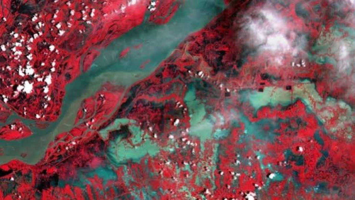
Assam floods have taken a worrying turn as new satellite imagery has revealed that the Brahmaputra River’s floodplain has expanded to nearly three times its normal width in several parts of the state. The latest findings highlight the massive scale of inundation caused by relentless rainfall, overflowing rivers, and widespread flooding across Assam. The images offer a clearer picture of the disaster, showing how rapidly floodwaters have spread across agricultural land, villages, forests, and transport networks.
Satellite Images Reveal the True Scale of Assam Floods
Recent satellite observations have captured the dramatic expansion of the Brahmaputra’s floodplain during the ongoing monsoon season. According to experts analysing the imagery, the river has spread across vast stretches of land, with the floodplain reaching nearly three times its usual extent in some areas.
The satellite data underscores the severity of the flooding that has affected multiple districts across Assam. Continuous rainfall over the Brahmaputra basin, combined with swollen tributaries, has led to widespread inundation. Several low-lying regions remain underwater, disrupting daily life and damaging critical infrastructure.
Scientists say satellite monitoring provides valuable real-time information that helps authorities assess flood severity, identify vulnerable areas, and coordinate rescue and relief operations more effectively.
Why the Brahmaputra Floodplain Expanded So Rapidly
The Brahmaputra is one of the world’s largest and most dynamic rivers, carrying enormous volumes of water during the monsoon. This year, heavy rainfall across Assam as well as upstream regions in Arunachal Pradesh, Bhutan, and neighbouring areas has significantly increased water discharge.
As water levels crossed danger marks at several monitoring stations, the river overflowed its banks, spreading across floodplains, wetlands, and agricultural fields. The combination of intense rainfall, saturated soil, and rising tributaries accelerated the expansion of floodwaters.
Experts note that the Brahmaputra naturally changes course and widens during the monsoon, but this year’s satellite imagery demonstrates an unusually extensive spread due to persistent rainfall and successive flood waves.
Humanitarian Impact of Assam Floods
The ongoing Assam floods have affected lakhs of people across numerous districts. Thousands of families have been forced to move to relief camps after floodwaters submerged homes and roads. Rescue teams from the National Disaster Response Force (NDRF), State Disaster Response Force (SDRF), the Army, and local administration continue evacuation and relief efforts.
The floods have damaged homes, schools, embankments, bridges, and public utilities. Agricultural fields growing paddy and other crops remain submerged, raising concerns over long-term economic losses for farmers.
Several rivers across Assam have continued to flow above the danger level, while fresh rainfall has complicated relief operations in many districts.
Wildlife and Environment Face Major Challenges
The expanding floodplain has also affected Assam’s rich biodiversity. National parks and wildlife sanctuaries located along the Brahmaputra basin have witnessed significant flooding, forcing animals to move to higher ground.
Authorities have increased monitoring in vulnerable wildlife habitats to reduce animal casualties and prevent human-wildlife conflict. Forest officials, volunteers, and conservation teams remain on alert as floodwaters continue to fluctuate.
Environmental experts believe satellite-based flood mapping will play an increasingly important role in monitoring ecosystem changes and planning future conservation strategies.
Government Response and Relief Measures
Both the Assam government and the Centre have intensified relief efforts in response to the disaster. Chief Minister Himanta Biswa Sarma has repeatedly reviewed the flood situation, directing officials to maintain rescue operations and ensure adequate supplies at relief camps.
Union Home Minister Amit Shah has assured all possible assistance from the Central government, including deploying central teams to assess the situation. The Indian Air Force has also remained on standby to support rescue operations if required.
Medical teams have been deployed to prevent disease outbreaks, while food, drinking water, medicines, and essential supplies continue to reach affected communities.
Technology Helping Disaster Management
Satellite technology has become an essential tool for disaster response during the Assam floods. High-resolution images enable authorities to monitor changing river channels, identify newly submerged areas, and estimate flood extent with greater accuracy.
These observations also assist disaster management agencies in planning rescue routes, prioritising relief distribution, and assessing damage after floodwaters recede. Experts believe integrating satellite data with weather forecasts and river monitoring systems can improve early warning capabilities and reduce future flood risks.
As climate variability increases the frequency of extreme weather events, such technologies will become even more important for flood-prone states like Assam.
Major Tripura Detention Centre Escape Raises Security Concerns After 18 Bangladeshi Immigrants Flee
Looking Ahead
The latest satellite images serve as a stark reminder of the immense power of the Brahmaputra during the monsoon. With the floodplain expanding nearly threefold in several locations, the ongoing crisis demonstrates the need for stronger flood management, resilient infrastructure, and better preparedness.
While rescue operations continue and thousands of affected residents await rehabilitation, scientific monitoring through satellite imagery is helping authorities understand the scale of the disaster more accurately. As weather agencies continue to forecast rainfall in the region, officials remain on high alert, hoping to minimise further damage and protect vulnerable communities from the continuing impact of the Assam floods.