

Sikkim has stepped up its preparedness against the threat of Glacial Lake Outburst Floods (GLOFs), with authorities identifying 40 glacial lakes as high-hazard sites and placing seven of them under heightened risk assessment and monitoring.
The state’s intensified focus on glacial hazards comes amid growing concern over climate-related disasters in the Himalayan region and follows detailed scientific studies conducted after the devastating South Lhonak Glacial Lake Outburst Flood in October 2023.
Sikkim’s mountainous terrain contains more than 400 glacial lakes of varying sizes, many of which are located in remote and ecologically fragile Himalayan regions. While a number of lakes have been identified as potentially hazardous, scientific investigations are being used to determine the actual level of vulnerability and the mitigation measures required for individual lake systems.
40 Glacial Lakes Identified as High-Hazard Sites
According to government assessments, 40 glacial lakes in Sikkim have been identified as high-risk or high-hazard lakes requiring scientific assessment and monitoring.
The identification of these lakes is based on factors including their location, size, water volume, surrounding geological conditions and the potential impact of a sudden outburst on downstream communities and infrastructure.
However, authorities are moving beyond broad satellite-based assessments and undertaking field-level scientific investigations to obtain a more precise understanding of individual risks.
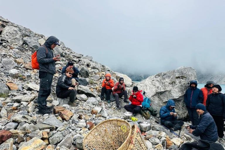
The Sikkim government’s Department of Science and Technology has carried out multidisciplinary expeditions involving specialists in glaciology, geology, geography, hydrology and engineering.
These expeditions are collecting information on lake depth, water volume, moraine stability, geological conditions, drainage characteristics and other factors that could influence the possibility and impact of a GLOF.
Seven Lakes Require Heightened Attention
Of the larger group of high-hazard glacial lakes, seven have emerged as requiring heightened attention based on detailed risk assessments.
Scientific teams are examining these lakes more closely to determine the potential consequences of sudden changes in water levels, moraine failure, landslides, avalanches or other events capable of triggering an outburst.
The distinction between a lake being classified as high-hazard and being considered at immediate or heightened risk is important. Authorities are seeking to develop lake-specific assessments rather than applying the same mitigation strategy across all vulnerable glacial lakes.
Sikkim’s government has increasingly focused on detailed field studies because each lake has different physical characteristics, including its water volume, outlet conditions, surrounding slopes and potential downstream flood pathways.
The state’s approach is aimed at identifying the most appropriate intervention for each location.
Shako Chho Identified as Most Vulnerable
Among the lakes under detailed assessment, Shako Chho in North Sikkim has emerged as one of the state’s most vulnerable glacial lakes.
The lake is located above Thangu and contains an estimated 27 million cubic metres of water. Scientific studies have prompted the state government to propose a solar-powered pumping system to gradually lower its water level.
Under the proposal, the pumping system would reduce the lake’s existing water level by around 20 metres over a period of two to three years.
The detailed project report has been forwarded for consideration as part of the state’s wider effort to reduce the potential consequences of a future glacial lake outburst.
Authorities believe that lowering water levels could reduce the volume of water available for a potential sudden release and strengthen overall risk mitigation.
Three Major Engineering Measures Proposed
Sikkim has proposed three major engineering interventions to address risks associated with vulnerable glacial lake systems.
The first proposal involves the solar-powered pumping system at Shako Chho to lower the lake’s water level.
The second proposal involves the construction of a flood-retention structure at Dolma Sampa in the Lhonak Valley. The structure is intended to slow down or reduce the destructive impact of a potential GLOF originating from the Lhonak lake complex.
The third intervention involves the construction of a safety wall or moraine-plug structure near the outlet of the Gurudongmar lake complex.
The proposals reflect a shift towards lake-specific mitigation strategies based on detailed scientific assessments. Rather than relying solely on monitoring and early warnings, authorities are also exploring physical interventions that could reduce the intensity of a flood before it reaches downstream communities and infrastructure.
Sensors and Early Warning Systems Strengthened
Alongside physical mitigation measures, Sikkim has significantly expanded its monitoring and early warning capabilities.
Authorities are continuously monitoring 16 highly vulnerable glacial lakes, with sensors, automated weather stations and early warning systems being deployed to detect changes that could indicate growing risks.
Sikkim has also become the first state in India to independently operate an end-to-end indigenous capability for glacial lake profiling and risk assessment.
The monitoring system includes water-level sensors capable of transmitting near-real-time information through satellite-based communication systems to a control centre in Gangtok.
Flood simulation models can also be used to estimate potential inundation areas and the likely arrival time of floodwaters in the event of a glacial lake outburst.
Such systems are considered critical because mountainous regions can experience sudden and rapidly developing disasters, leaving downstream communities with very limited time to respond.
Lessons From the 2023 South Lhonak Disaster
Sikkim’s intensified preparedness efforts have been strongly influenced by the catastrophic South Lhonak GLOF of October 2023.
The disaster caused widespread destruction in the Teesta river basin, affecting communities and infrastructure across the state.
The flood resulted in fatalities, left several people missing and damaged bridges and other critical infrastructure. The South Lhonak event also severely affected the Chungthang region and caused extensive damage to hydropower infrastructure.
Scientific studies have since examined the sequence of events behind the disaster, while state and central agencies have expanded their efforts to understand and mitigate similar risks from other glacial lakes.
The 2023 tragedy demonstrated the destructive potential of high-altitude glacial floods and the importance of combining scientific monitoring with disaster preparedness and physical risk-reduction measures.
Himalayan Climate Risks Raise Fresh Concerns
The issue has gained renewed urgency following recent glacier-related disasters in the Himalayan region.
Rapid glacier retreat, changing temperatures, extreme rainfall and geological instability can create complex and interconnected hazards in high mountain environments.
As glaciers retreat, new lakes can form or existing lakes can expand. Changes in the stability of surrounding slopes, moraine barriers and ice formations can also increase uncertainty.
Experts have warned that climate change is increasing the urgency of improving monitoring, hazard mapping and early warning systems across the Himalayas.
The Indian government has also accelerated work on early warning systems for hundreds of critical lakes across the Indian Himalayan Region as concern over glacial flood hazards grows.
Scientific Field Expeditions Continue in Sikkim
The Sikkim government has continued sending multidisciplinary teams to remote high-altitude regions to collect detailed scientific data.
A recent expedition in Mangan district focused on generating baseline information needed for hazard assessment, monitoring and mitigation planning.
Scientists conducted bathymetric, geological, geophysical, hydrological, geomorphological and meteorological investigations at vulnerable glacial lake systems.
Such field studies are particularly important because satellite observations alone cannot always provide a complete picture of conditions beneath the water surface or within the geological structures surrounding a lake.
The data collected through these expeditions is expected to help authorities refine risk assessments and prioritise future mitigation measures.
Sikkim Glacial Lake Flood Risk Remains a Major Concern
The Sikkim glacial lake flood risk remains a major concern because of the state’s Himalayan geography and the presence of numerous glacial lakes above populated valleys and critical infrastructure.
The identification of 40 high-hazard lakes and the closer assessment of seven high-risk locations underline the scale of the challenge facing authorities.
Sikkim is now combining scientific field assessments, indigenous monitoring technology, early warning systems and proposed engineering interventions to strengthen its preparedness.
The state’s experience following the South Lhonak disaster has highlighted the need to treat glacial hazards as a long-term challenge rather than an occasional emergency.
With monitoring systems being strengthened and mitigation proposals under consideration, Sikkim is seeking to reduce the potential impact of future GLOFs on communities, roads, bridges and hydropower infrastructure.
As climate and environmental conditions continue to change across the Himalayas, sustained scientific monitoring and timely intervention will remain essential to protecting vulnerable downstream populations from one of the region’s most unpredictable natural hazards.