

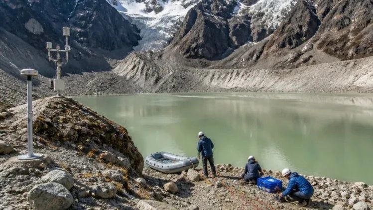
Sikkim has completed its first comprehensive field-based study of high-risk glacial lakes, marking an important step in strengthening the state’s preparedness against Glacial Lake Outburst Floods, or GLOFs.
The study examined nine high-risk glacial lakes and generated detailed information about their physical conditions, water storage and surrounding geological features. Scientists conducted the assessment between 2022 and 2025, using extensive ground-based investigations rather than relying only on satellite observations.
The findings are expected to support more accurate GLOF hazard assessments and lake-specific mitigation plans. They could also help authorities strengthen monitoring and early-warning systems in vulnerable Himalayan areas. The research findings have been published in the journal Natural Hazards in 2026.
The study has gained added importance because Sikkim remains highly vulnerable to glacial hazards. The October 2023 South Lhonak Lake outburst caused devastating flooding and demonstrated the destructive potential of sudden releases from glacial lakes.
Field-Based Study Examines Nine High-Risk Lakes
The Sikkim high-risk glacial lakes study focused on nine lakes identified as vulnerable to potential GLOF hazards.
Scientists from the Sikkim Science and Technology Department, Sikkim University and other partner institutions carried out the research. Their objective was to develop detailed and site-specific information for disaster preparedness and mitigation planning.
Unlike studies based mainly on satellite imagery, the latest assessment involved direct field investigations. Scientists physically examined the lakes and their surrounding terrain to understand conditions that may influence their stability.
Field-based research can reveal details that satellite images may not fully capture. These include the internal condition of moraine dams, the presence of buried ice and possible seepage pathways.
Such information is important because glacial lakes are often held back by natural dams made of loose rock, soil and glacial debris.
Changes within these natural barriers can influence the risk of an outburst.
The detailed field assessment therefore represents an important step towards developing more reliable mitigation strategies.
Scientists Measure Lake Depth and Water Volume
One of the major parts of the study involved bathymetric surveys.
Bathymetry allows scientists to measure the actual depth and underwater shape of a lake. These measurements can provide a clearer estimate of the total volume of water stored inside the lake.
The amount of water stored in a glacial lake is an important factor in assessing the potential consequences of a GLOF.
The study found significant differences in the size and water storage capacity of the lakes examined.
Khangchung Chho emerged as one of the most significant lakes in terms of water storage. It reportedly holds more than 125 million cubic metres of water, making it considerably larger than several other lakes assessed during the study.
Accurate measurements can help scientists develop more realistic flood scenarios.
Authorities can then use these findings to estimate possible downstream impacts and prepare suitable mitigation measures.
This information can also help identify communities, roads, bridges and other infrastructure that could face greater risk during a major outburst.
Moraine Dams Studied for Hidden Vulnerabilities
The research also focused on the stability of moraine dams.
These natural dams often form when glaciers retreat and leave behind large deposits of rock and sediment. A glacial lake may develop behind these deposits.
However, the visible surface of a moraine dam does not always reveal its internal condition.
Scientists therefore used advanced techniques to investigate possible hidden weaknesses.
The field studies examined saturated zones, buried ice and seepage pathways inside or beneath the moraine structures.
Such conditions can affect the long-term stability of the natural barriers.
Electrical Resistivity Tomography, or ERT, has become an important tool in these assessments. The technique helps researchers investigate underground conditions without extensive excavation.
Sikkim’s earlier field expeditions also used ERT to study the internal structure of moraine dams at vulnerable glacial lakes.
The state government has said such field-based data is crucial for understanding buried ice, saturated zones and possible seepage pathways that may influence GLOF risk.
GLOF Threat Remains a Major Concern for Sikkim
A Glacial Lake Outburst Flood occurs when a large quantity of water stored in a glacial lake is suddenly released.
The resulting flood can travel rapidly downstream and carry water, rocks, sediment and debris.
Communities and infrastructure located along river valleys can face severe consequences.
The threat received major attention in Sikkim after the South Lhonak Lake outburst in October 2023.
The disaster caused widespread destruction downstream and reinforced the need for stronger scientific monitoring and mitigation planning.
Government and scientific agencies have since increased their focus on vulnerable lakes.
Sikkim has identified 40 high-risk glacial lakes, while several lakes have received priority for detailed scientific assessments and mitigation planning.
The latest field-based study forms part of this wider effort to better understand and reduce glacial flood risks.
Study Supports Lake-Specific Mitigation Plans
One of the key goals of the research is to move beyond general assessments.
Different glacial lakes have different physical conditions and risk factors. A single mitigation approach may therefore not work for every lake.
Scientists need detailed information about each lake before recommending a specific intervention.
The field-based study can support the preparation of lake-specific GLOF mitigation plans.
Possible measures may include improved monitoring, early-warning systems and engineering interventions designed according to the conditions of individual lakes.
Sikkim’s Science and Technology Department has adopted a broader approach involving preliminary assessment, comprehensive field-based assessment, mitigation planning and long-term monitoring.
The state has also undertaken hydrological, geological, bathymetric and geophysical investigations to develop detailed project reports for priority lakes.
This approach aims to ensure that mitigation decisions are based on scientific evidence.
Advanced Technology Strengthens Scientific Monitoring
Modern technology has played an important role in Sikkim’s glacial hazard studies.
Scientists have used bathymetric surveys, DGPS measurements, hydrological observations, geomorphological investigations and geophysical techniques.
Field expeditions have also used meteorological monitoring systems and other equipment to collect continuous environmental data.
During a multidisciplinary expedition in Mangan district in July and August 2026, the state government collected bathymetric, geological, geophysical, hydrological and meteorological information from vulnerable glacial lake systems.
The expedition also used ERT, DGPS surveys and hydrological measurements and deployed a meteorological monitoring station at Kerang and Goma Chhu.
Such detailed datasets can improve the accuracy of future hazard models.
They can also help scientists understand how changing weather, glacier behaviour and terrain conditions influence glacial lake risks.
Early Warning and Preparedness Remain Important
Scientific assessment alone cannot eliminate the risk of a GLOF.
Authorities also need effective monitoring and early-warning mechanisms.
Early-warning systems can provide valuable time for authorities and communities to respond when unusual changes occur.
Monitoring equipment can track environmental conditions and provide data that may indicate changing risks.
Sikkim has continued to emphasise scientific monitoring and preparedness as part of its broader GLOF mitigation strategy.
The state is also exploring flood-control and water-management measures at vulnerable glacial lake systems.
Government agencies have proposed specific mitigation projects for priority lakes based on detailed scientific assessments.
The combination of scientific research, technology and disaster preparedness could help reduce the potential impact of future glacial hazards.
Sikkim Moves Towards Stronger Climate Resilience
The completion of the comprehensive field-based study represents a significant milestone for Sikkim’s disaster risk reduction efforts.
The study provides detailed information that can help authorities understand risks that may not be visible through satellite images alone.
Direct field investigations have allowed scientists to examine lake depths, water volumes, moraine stability and hidden geological conditions.
These findings can support better risk modelling and practical mitigation planning.
Sikkim’s efforts are particularly important as climate-related changes continue to increase concerns across the Himalayan region.
The state now plans to use scientific evidence to strengthen monitoring, prepare mitigation projects and improve protection for downstream communities.
Field-Based Research Marks Major Step for GLOF Mitigation
Sikkim’s completion of its first comprehensive field-based study of high-risk glacial lakes marks an important advance in the state’s GLOF mitigation efforts.
The assessment of nine vulnerable lakes has provided scientists and authorities with detailed information about their physical and geological conditions.
The research can now support lake-specific mitigation strategies rather than relying on broad assumptions.
Accurate information about water volumes, moraine stability and hidden vulnerabilities will help authorities make better decisions.
The study also reinforces the importance of continued scientific monitoring in the Himalayas.
As Sikkim works to reduce the risk of future glacial floods, field-based research, advanced technology and early-warning systems will remain central to its disaster preparedness strategy.
The findings could help the state develop stronger and more practical measures to protect communities, infrastructure and ecosystems located downstream of vulnerable glacial lakes.